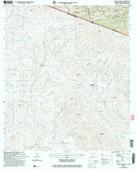
2004 Map of Alamo Spring
USGS Topo · Published 2007About this map
The international border between the United States and Mexico bisects this landscape, marking the transition from Santa Cruz County, Arizona, into Sonora. The northern portion is dominated by the Coronado National Forest and the Pajarita Wilderness, a region defined by the sharp rise of the Pajarita Mountains. To the south, the terrain of the Sierra Esmeralda is carved by an intricate network of drainage systems, including Arroyo el Alamo and Arroyo Real Viejo.
Find a feature on this map
64 named features on this map. Tap any name to fly to it.
Don’t see what you’re looking for? This feature index may not catch every label — zoom into the map to look around manually.
Map Details
Editions of this 2004 Alamo Spring Map
This is the sole edition of this map. No revisions or reprints were ever made.
Other maps of this area

1921 · Old Glory
USGS Topo · 1:125,000

1942 · Ruby
USGS Topo · 1:62,500

1942 · Oro Blanco
USGS Topo · 1:62,500

1943 · Old Glory
USGS Topo · 1:125,000

1944 · Oro Blanco
USGS Topo · 1:62,500

1956 · Nogales
USGS Topo · 1:250,000
1957 · Ruby
USGS Topo · 1:62,500

1958 · Nogales
USGS Topo · 1:250,000

1959 · Nogales
USGS Topo · 1:250,000
1979 · Bartlett Mtn
USGS Topo · 1:24,000