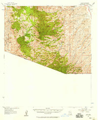
1957 Map of Ruby
USGS Topo · Published 1958About this map
Mining operations and ranching outposts define this borderland landscape within the Coronado National Forest during the mid-20th century. The settlement of Ruby serves as a central hub for the district, situated near the Montana Peak and the Cem. The map reveals a high concentration of mineral interest along the southern ridges, including the Dos Amigos Mine, Morning Mine, and Old Bashful Mine. These sites sit amidst a complex network of canyons and peaks, with the Atascosa Mountains and Pajarito Mountains dominating the vertical relief.
Find a feature on this map
65 named features on this map. Tap any name to fly to it.
Don’t see what you’re looking for? This feature index may not catch every label — zoom into the map to look around manually.
Map Details
Editions of this 1957 Ruby Map
3 editions found
Other maps of this area

1904 · Patagonia
USGS Topo · 1:125,000

1905 · Patagonia
USGS Topo · 1:125,000

1905 · Nogales
USGS Topo · 1:125,000

1920 · Arivaca
USGS Topo · 1:125,000

1921 · Old Glory
USGS Topo · 1:125,000

1922 · Agus Caliente
USGS Topo · 1:62,500

1933 · Calabasas
USGS Topo · 1:62,500

1939 · Tubac
USGS Topo · 1:62,500

1941 · Arivaca
USGS Topo · 1:62,500

1942 · Ruby
USGS Topo · 1:62,500