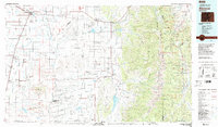
1983 Map of Alamosa
USGS Topo · Published 1983About this map
Alamosa serves as the focal point for this 1980s landscape, where the flat floor of the San Luis Valley meets the steep rise of the Sangre de Cristo Mountains. The Rio Grande and its many tributaries, including the Conejos River and Trinchera Creek, dictate the settlement patterns of traditional Hispanic plazas and agricultural centers like San Luis and San Pablo. Large-scale land management is evident through the Alamosa National Wildlife Refuge and the sprawling San Isabel National Forest.
Find a feature on this map
77 named features on this map. Tap any name to fly to it.
Don’t see what you’re looking for? This feature index may not catch every label — zoom into the map to look around manually.
Map Details
Editions of this 1983 Alamosa Map
2 editions found
Other maps of this area

1889 · Huerfano Park
USGS Topo · 1:125,000

1891 · Walsenburg
USGS Topo · 1:125,000

1891 · Spanish Peaks
USGS Topo · 1:125,000

1892 · Huerfano Park
USGS Topo · 1:125,000

1893 · Spanish Peaks
USGS Topo · 1:125,000

1894 · Walsenburg
USGS Topo · 1:125,000

1895 · Spanish Peaks
USGS Topo · 1:125,000

1897 · Walsenburg
USGS Topo · 1:125,000

1897 · Spanish Peaks
USGS Topo · 1:125,000

1900 · Spanish Peaks
USGS Topo · 1:125,000