1893 Map of Albany
USGS Topo · Published 1893About this map
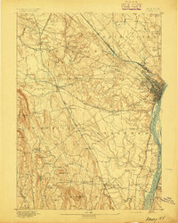
Albany is depicted here at a pivotal moment of late 19th-century expansion, where the dense urban grid meets a complex web of river commerce and heavy rail. The Hudson River is the focal point of the eastern edge, dotted with named landforms like Westerlo Island and Papscanee Island, reflecting an era before modern industrial dredging altered the channel's character. Inland, the landscape is defined by the convergence of the New York Central and Hudson River Railroad and the West Shore Railroad Albany Branch, which spurred the growth of surrounding townships like Bethlehem and Guilderland. This survey captures numerous vanished crossroads and smaller hamlets such as French Mills and Ireland Corner, providing a look at the rural-to-suburban transition. From the heights of Countryman Hill to the wetlands along Normans Kill, the map detail reveals the family-named landmarks and local creeks that shaped the area's early development.
Find a feature on this map
84 named features on this map. Tap any name to fly to it.
Don’t see what you’re looking for? This feature index may not catch every label — zoom into the map to look around manually.
Map Details
Editions of this 1893 Albany Map
2 editions found
Other maps of this area

1893 · Cohoes
USGS Topo · 1:62,500

1893 · Troy
USGS Topo · 1:62,500

1893 · Schenectady
USGS Topo · 1:62,500

1893 · Coxsackie
USGS Topo · 1:62,500

1893 · Durham
USGS Topo · 1:62,500

1893 · Albany
USGS Topo · 1:62,500

1894 · Coxsackie
USGS Topo · 1:62,500

1894 · Durham
USGS Topo · 1:62,500

1895 · Troy
USGS Topo · 1:62,500

1895 · Cohoes
USGS Topo · 1:62,500