
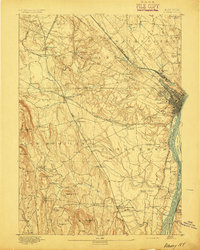
1893 Map of Albany
USGS Topo · Published 1893About this map
The Hudson River serves as the bustling arterial heart of this 1890s survey, where the city of Albany anchors a massive rail-and-water network. Numerous islands like Westerlo Island and Papscanee Island divide the river channels, while the Albany Rensselaer County Line follows the river's path. Moving inland, the terrain rises into the Helderberg Mountains, featuring prominent peaks such as Countryman Hill and Wolf Hill.
Find a feature on this map
88 named features on this map. Tap any name to fly to it.
Don’t see what you’re looking for? This feature index may not catch every label — zoom into the map to look around manually.
Map Details
Editions of this 1893 Albany Map
2 editions found
Other maps of this area

1893 · Cohoes
USGS Topo · 1:62,500

1893 · Troy
USGS Topo · 1:62,500

1893 · Schenectady
USGS Topo · 1:62,500

1893 · Coxsackie
USGS Topo · 1:62,500

1893 · Durham
USGS Topo · 1:62,500

1894 · Coxsackie
USGS Topo · 1:62,500

1894 · Durham
USGS Topo · 1:62,500

1895 · Troy
USGS Topo · 1:62,500

1895 · Cohoes
USGS Topo · 1:62,500

1895 · Albany
USGS Topo · 1:62,500