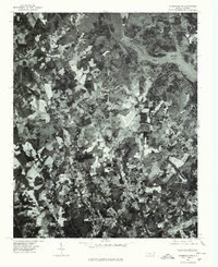
1977 Map of Albemarle NW
USGS Topo · Published 1979About this map
New London and the surrounding Stanly County countryside are captured in this orthophotomap during the late 1970s. This specific aerial perspective reveals the mosaic of woodlots and agricultural clearings that defined the region before modern suburban expansion. The town of New London serves as a central hub, while smaller crossroads and communities like Isenhour and Palestine are visible along the local road network.
Find a feature on this map
7 named features on this map. Tap any name to fly to it.
Don’t see what you’re looking for? This feature index may not catch every label — zoom into the map to look around manually.
Map Details
Editions of this 1977 Albemarle NW Map
This is the sole edition of this map. No revisions or reprints were ever made.
Other maps of this area

1949 · High Rock
USGS Topo · 1:24,000

1953 · Charlotte
USGS Topo · 1:250,000

1954 · Charlotte
USGS Topo · 1:250,000

1957 · Mount Pleasant
USGS Topo · 1:62,500

1957 · Albemarle
USGS Topo · 1:62,500

1957 · Denton
USGS Topo · 1:62,500

1960 · Charlotte
USGS Topo · 1:250,000

1962 · Charlotte
USGS Topo · 1:250,000
1962 · Gold Hill
USGS Topo · 1:24,000
1977 · High Rock
USGS Topo · 1:24,000