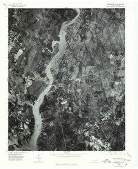
1977 Map of Albemarle SE
USGS Topo · Published 1979About this map
Pee Dee River and Lake Tillery define this landscape along the border of Montgomery County in the late 1970s. This orthophotoquad captures the transition from the ancient elevations of the Uwharrie Mts and Morrow Mtn down to the water’s edge. The imagery reveals the development patterns typical of this era, with residential concentrations appearing at River Haven and the settlement of Pee Dee. Unlike a traditional topographic map, this photographic survey provides a literal view of the forest cover and cleared land surrounding the reservoir, showing the exact footprint of shoreline properties and rural farmsteads as they existed during the March 1977 aerial survey. Local roads and highways, including routes 24 27 and 73, provide the primary framework for the scattered settlements in this river valley region.
Find a feature on this map
8 named features on this map. Tap any name to fly to it.
Don’t see what you’re looking for? This feature index may not catch every label — zoom into the map to look around manually.
Map Details
Editions of this 1977 Albemarle SE Map
This is the sole edition of this map. No revisions or reprints were ever made.
Other maps of this area

1942 · Troy
USGS Topo · 1:125,000

1953 · Raleigh
USGS Topo · 1:250,000

1953 · Charlotte
USGS Topo · 1:250,000

1954 · Charlotte
USGS Topo · 1:250,000

1954 · Raleigh
USGS Topo · 1:250,000

1956 · Mount Gilead East
USGS Topo · 1:24,000

1956 · Mount Gilead West
USGS Topo · 1:24,000

1957 · Albemarle
USGS Topo · 1:62,500

1957 · Troy
USGS Topo · 1:62,500

1960 · Charlotte
USGS Topo · 1:250,000