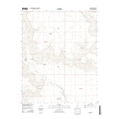
2013 Map of Albert
USGS Topo · Published 2013About this map
Tequesquite Cr and Carrizo Cr carve a complex network of drainages through the high plains of northeastern New Mexico, defining the isolated settlement of Albert. This landscape is characterized by its dramatic vertical relief, where flat-topped landforms like Mesa Quitaras stand above deep incisions such as Lalo Canyon, Plum Rincon Canyon, and Asperos Canyon. The cartography reveals a sparse but established ranching infrastructure, centered around the Albert PO and the Tequesquite Ranch Airport. Local water sources, including Reveal Springs, remain critical landmarks in this arid environment. The map provides a detailed view of the township and range system, showing the transition between t20n r29e and t21n r30e, while Tequesquite Ln serves as the primary corridor through the rugged Tequesquite Canyon floor.
Find a feature on this map
18 named features on this map. Tap any name to fly to it.
Don’t see what you’re looking for? This feature index may not catch every label — zoom into the map to look around manually.
Map Details
Editions of this 2013 Albert Map
This is the sole edition of this map. No revisions or reprints were ever made.
Other maps of this area

1954 · Tucumcari
USGS Topo · 1:250,000

1954 · Dalhart
USGS Topo · 1:250,000

1958 · Tucumcari
USGS Topo · 1:250,000

1958 · Dalhart
USGS Topo · 1:250,000

1962 · Dalhart
USGS Topo · 1:250,000

1973 · Circle Bar Ranch
USGS Topo · 1:24,000

1973 · Yates SE
USGS Topo · 1:24,000

1973 · Mosquero
USGS Topo · 1:24,000

1973 · Sabino
USGS Topo · 1:24,000
1973 · Bueyeros
USGS Topo · 1:24,000