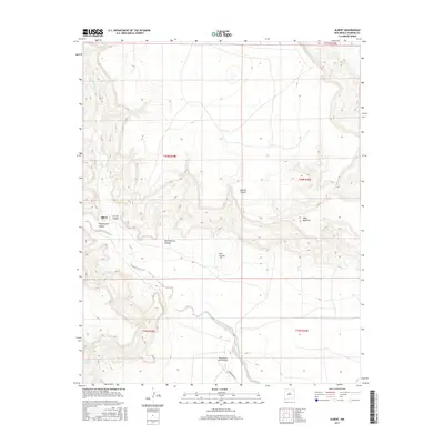
2017 Map of Albert
USGS Topo · Published 2017About this map
Albert sits at the convergence of high-desert drainage systems in this part of Harding County, where the landscape is defined by a network of deep-cut canyons and ephemeral watercourses. The local topography is dominated by dramatic elevation changes at Mesa Quitaras and a series of erosion-carved features including Carrizo Canyon, Plum Rincon Canyon, and Lalo Canyon. The ranching character of the region is evident in the infrastructure surrounding the Tequesquite Ranch Airport, which serves as a remote hub for the area. Water sources remain central to life here, as shown by the winding paths of Carrizo Cr and Tequesquite Cr, along with the isolated Revival Springs. Modern access is limited primarily to Tequesquite Rd, illustrating the secluded nature of this High Plains settlement.
Find a feature on this map
17 named features on this map. Tap any name to fly to it.
Don’t see what you’re looking for? This feature index may not catch every label — zoom into the map to look around manually.
Map Details
Editions of this 2017 Albert Map
This is the sole edition of this map. No revisions or reprints were ever made.
Other maps of this area

1954 · Tucumcari
USGS Topo · 1:250,000

1954 · Dalhart
USGS Topo · 1:250,000

1958 · Tucumcari
USGS Topo · 1:250,000

1958 · Dalhart
USGS Topo · 1:250,000

1962 · Dalhart
USGS Topo · 1:250,000

1973 · Circle Bar Ranch
USGS Topo · 1:24,000

1973 · Yates SE
USGS Topo · 1:24,000

1973 · Mosquero
USGS Topo · 1:24,000

1973 · Sabino
USGS Topo · 1:24,000
1973 · Bueyeros
USGS Topo · 1:24,000