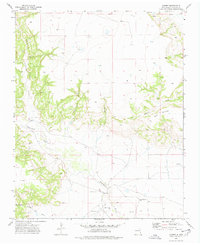
1973 Map of Albert
USGS Topo · Published 1978About this map
Albert serves as the focal point of this high-plains landscape in Harding County during the early 1970s. The map illustrates a sparse but established settlement pattern where local education and communication are centered at Albert Academy and the Albert PO. The terrain is defined by dramatic geological breaks, including the deep incisions of Plum Rincon Canyon and Lalo Canyon as they drop toward the Tequesquite Creek valley. A notable shift in the local economy is evidenced by the presence of a Carbon Dioxide Well and a Drill Hole in the southern sections, signaling industrial interest in subsurface resources alongside traditional ranching. For genealogists, several small Cem sites and a single Grave are recorded, providing specific points of interest for family history research in this rural portion of Northeastern New Mexico.
Find a feature on this map
20 named features on this map. Tap any name to fly to it.
Don’t see what you’re looking for? This feature index may not catch every label — zoom into the map to look around manually.
Map Details
Editions of this 1973 Albert Map
This is the sole edition of this map. No revisions or reprints were ever made.
Other maps of this area

1954 · Tucumcari
USGS Topo · 1:250,000

1954 · Dalhart
USGS Topo · 1:250,000

1958 · Tucumcari
USGS Topo · 1:250,000

1958 · Dalhart
USGS Topo · 1:250,000

1962 · Dalhart
USGS Topo · 1:250,000

1973 · Circle Bar Ranch
USGS Topo · 1:24,000

1973 · Yates SE
USGS Topo · 1:24,000

1973 · Mosquero
USGS Topo · 1:24,000

1973 · Sabino
USGS Topo · 1:24,000
1973 · Bueyeros
USGS Topo · 1:24,000