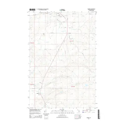
2014 Map of Alberta
USGS Topo · Published 2014About this map
L'Anse and the surrounding timberlands of Baraga County are defined by a network of waterways that cascade toward Lake Superior. The northern reaches of this territory are anchored by L'Anse Township Cem and the small settlement of Bovine, while the southern landscape transitions into the planned industrial community of Alberta. The dramatic topography is highlighted by the Falls River, which features a series of significant drops including Power House Falls and Power Dam Falls. Local history and genealogy are tied to the roads that navigate these woods, such as Herman Rd and Old 41 Rd S. Away from the main transit corridors like Us-41, the terrain is punctuated by isolated water bodies including Kontio Lake and the Jackson Lakes, alongside numerous minor tributaries like Roubillard Cr and Denomie Cr that cut through the high ground near Little Mtn.
Find a feature on this map
58 named features on this map. Tap any name to fly to it.
Don’t see what you’re looking for? This feature index may not catch every label — zoom into the map to look around manually.
Map Details
Editions of this 2014 Alberta Map
This is the sole edition of this map. No revisions or reprints were ever made.
Other maps of this area

1954 · Keweenaw Bay
USGS Topo · 1:62,500

1954 · Pelkie
USGS Topo · 1:62,500

1954 · Sidnaw
USGS Topo · 1:62,500

1955 · Herman
USGS Topo · 1:62,500

1958 · Iron River
USGS Topo · 1:250,000

1960 · Iron River
USGS Topo · 1:250,000

1961 · Iron River
USGS Topo · 1:250,000

1967 · Iron River
USGS Topo · 1:250,000
1984 · Aura
USGS Topo · 1:24,000
1985 · L'Anse
USGS Topo · 1:24,000