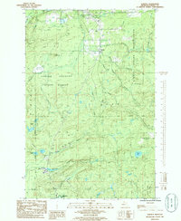
1985 Map of Alberta
USGS Topo · Published 1986About this map
Alberta sits at the southwestern corner of this survey, surrounded by the dense woods of the Copper Country State Forest. The landscape is defined by the complex hydrology of the Sturgeon River basin, with numerous tributaries like Plumbago Creek and Bacco Creek draining the timberlands. In the north, the small settlement of Bovine and the Secret Falls Trailer Park are positioned near the L'Anse Indian Reservation boundary. Industrial markers of the mid-1980s are evident in the form of an Open Pit Mine and an Industrial Waste Water Sprinkler System. This era in Baraga County highlights a transitional period where traditional land use, including the lingering traces of an Old RR Grade, met modern resource management and infrastructure, such as the Microwave Tower near Kontio Lake.
Find a feature on this map
42 named features on this map. Tap any name to fly to it.
Don’t see what you’re looking for? This feature index may not catch every label — zoom into the map to look around manually.
Map Details
Editions of this 1985 Alberta Map
This is the sole edition of this map. No revisions or reprints were ever made.
Other maps of this area

1954 · Keweenaw Bay
USGS Topo · 1:62,500

1954 · Pelkie
USGS Topo · 1:62,500

1954 · Sidnaw
USGS Topo · 1:62,500

1955 · Herman
USGS Topo · 1:62,500

1958 · Iron River
USGS Topo · 1:250,000

1960 · Iron River
USGS Topo · 1:250,000

1961 · Iron River
USGS Topo · 1:250,000

1967 · Iron River
USGS Topo · 1:250,000
1984 · Aura
USGS Topo · 1:24,000
1985 · L'Anse
USGS Topo · 1:24,000