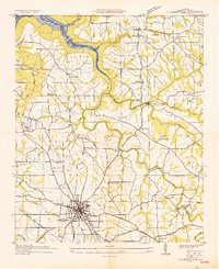
1936 Map of Albertville
USGS Topo · Published 1936About this map
Albertville sits at the southern end of this survey, acting as a regional hub where the Chattanooga and St Louis railroad meets highways Hy No 241 and Hy No 32. The landscape is defined by the broad plateau of Sand Mountain, which is bisected by the Tennessee River Divide. To the north, the terrain drops toward the newly mapped Guntersville Reservoir, a project of the Tennessee Valley Authority that fundamentally altered the course of Short Creek and its surrounding hollows.
Find a feature on this map
60 named features on this map. Tap any name to fly to it.
Don’t see what you’re looking for? This feature index may not catch every label — zoom into the map to look around manually.
Map Details
Editions of this 1936 Albertville Map
This is the sole edition of this map. No revisions or reprints were ever made.
Other maps of this area

1885 · Gadsden
USGS Topo · 1:125,000

1888 · Gadsden
USGS Topo · 1:125,000

1892 · Gadsden
USGS Topo · 1:125,000

1895 · Gadsden
USGS Topo · 1:125,000

1903 · Gadsden
USGS Topo · 1:125,000

1936 · Painter
USGS Topo · 1:24,000

1936 · Guntersville
USGS Topo · 1:24,000

1936 · Mountainboro
USGS Topo · 1:24,000

1936 · Columbus City
USGS Topo · 1:24,000

1936 · Rodentown
USGS Topo · 1:24,000