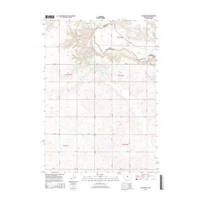
2015 Map of Alcester NE
USGS Topo · Published 2015About this map
The Big Sioux River meanders across the border between South Dakota and Iowa, defining the natural boundary between Lincoln and Sioux counties. This 2015 survey documents a landscape dominated by agriculture and divided by a strictly rectilinear grid of section roads like 480th Ave and 290th St. The small settlement of Moe sits in the southwestern portion of the map, while historical sites such as Bethany Cem and North Trinity Cem serve as quiet markers of the area's ancestral roots. Several significant drainages, including Sargeant Cr, Pattee Cr, and E Brule Cr, feed into the river system, illustrating the hydrology of this fertile borderland. The township structure remains central to the region's organization, with clearly marked sections across T97N R48W and T96N R49W.
Find a feature on this map
32 named features on this map. Tap any name to fly to it.
Don’t see what you’re looking for? This feature index may not catch every label — zoom into the map to look around manually.
Map Details
Editions of this 2015 Alcester NE Map
This is the sole edition of this map. No revisions or reprints were ever made.
Other maps of this area

1897 · Canton
USGS Topo · 1:125,000

1900 · Canton
USGS Topo · 1:125,000

1955 · Sioux Falls
USGS Topo · 1:250,000

1958 · Sioux Falls
USGS Topo · 1:250,000

1962 · Canton
USGS Topo · 1:24,000

1964 · Canton SW
USGS Topo · 1:24,000

1968 · Alcester NW
USGS Topo · 1:24,000

1968 · Alcester NE
USGS Topo · 1:24,000
1968 · Alcester
USGS Topo · 1:24,000
1968 · Alcester SE
USGS Topo · 1:24,000