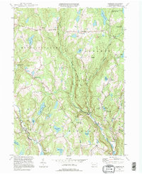
1994 Map of Aldenville
USGS Topo · Published 1995About this map
The West Branch Lackawaxen River and several major tributaries, including Middle Branch Dyberry Creek, define this pocket of Wayne County as it appeared in the mid-1990s. Historic transport routes like the Newburgh Turnpike and the Bethany Turnpike cut through the townships of Mount Pleasant, Lebanon, and Dyberry, connecting small settlements like Niagara and Whites Valley. The landscape is dotted with numerous glacial ponds and lakes, such as Long Pond and Miller Pond, which support a variety of seasonal camps including Camp Cayuga and Camp Towanda. Local heritage is anchored by sites like St Cecelia Ch and Hulls Cem near Red Schoolhouse Corner. Further south, the Himalayan Institute and the Prompton Recreation Area signify the area's later development as a destination for education and outdoor activity, while the settlement of Aldenville remains a primary waypoint along the river.
Find a feature on this map
51 named features on this map. Tap any name to fly to it.
Don’t see what you’re looking for? This feature index may not catch every label — zoom into the map to look around manually.
Map Details
Editions of this 1994 Aldenville Map
This is the sole edition of this map. No revisions or reprints were ever made.
Other maps of this area

1892 · Honesdale
USGS Topo · 1:62,500

1920 · Long Eddy
USGS Topo · 1:62,500

1920 · Damascus
USGS Topo · 1:62,500

1921 · Long Eddy
USGS Topo · 1:48,000

1923 · Damascus
USGS Topo · 1:62,500

1923 · Long Eddy
USGS Topo · 1:62,500

1926 · Starrucca
USGS Topo · 1:62,500

1930 · Starrucca
USGS Topo · 1:48,000

1933 · Starrucca
USGS Topo · 1:62,500

1943 · Honesdale
USGS Topo · 1:125,000