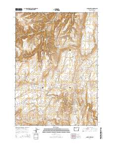
2014 Map of Alder Creek
USGS Topo · Published 2014About this map
Red Butte and the surrounding high desert of Malheur County define this landscape, where water management is central to the local geography. Numerous small reservoirs, including Red Butte Reservoir Number One and Red Butte Reservoir Number Two, dot the drainage basins to support ranching or irrigation in this arid corner of Oregon. The presence of Littlefield Cem near Crowley Rd offers a point of interest for genealogists tracing family histories in the remote ranchlands south of Harper. Natural water sources like Alder Creek Spring and Black Bull Spring feed into the complex system of seasonal creeks such as Cottonwood Cr and Skull Cr. The transit network is primarily composed of unpaved access routes like the Shumway Cutoff Rd, which navigates the terrain between Red Basin and the various gulches and draws.
Find a feature on this map
35 named features on this map. Tap any name to fly to it.
Don’t see what you’re looking for? This feature index may not catch every label — zoom into the map to look around manually.
Map Details
Editions of this 2014 Alder Creek Map
This is the sole edition of this map. No revisions or reprints were ever made.
Other maps of this area

1955 · Boise
USGS Topo · 1:250,000

1958 · Boise
USGS Topo · 1:250,000

1962 · Boise
USGS Topo · 1:250,000

1972 · Tims Peak
USGS Topo · 1:24,000

1972 · Shumway Reservoir
USGS Topo · 1:24,000

1972 · Alder Creek
USGS Topo · 1:24,000

1972 · Avery Creek
USGS Topo · 1:24,000

1972 · Rufino Butte
USGS Topo · 1:24,000

1972 · Copeland Reservoirs
USGS Topo · 1:24,000
1972 · Skull Springs
USGS Topo · 1:24,000