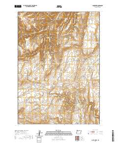
2020 Map of Alder Creek
USGS Topo · Published 2020About this map
Littlefield Cem sits along the southeastern reach of this high-desert landscape in Malheur County, providing a point of interest for genealogists tracing local history. The terrain is characterized by a complex network of ephemeral drainages and springs that feed numerous livestock reservoirs, such as McKay Reservoir, Pigtail Reservoir, and Tin Can Reservoir. Prominent landmarks like Red Butte and Rufino Butte rise above the surrounding basin, while Rufino Gulch cuts through the northeast. This area remains largely defined by its ranching infrastructure, connected by remote paths like Crowley Rd and Shumway Cutoff Rd. The sheer density of named water features, including Black Bull Spring and Palmer Spring, highlights the critical importance of water management in this arid stretch of eastern Oregon.
Find a feature on this map
39 named features on this map. Tap any name to fly to it.
Don’t see what you’re looking for? This feature index may not catch every label — zoom into the map to look around manually.
Map Details
Editions of this 2020 Alder Creek Map
This is the sole edition of this map. No revisions or reprints were ever made.
Other maps of this area

1955 · Boise
USGS Topo · 1:250,000

1958 · Boise
USGS Topo · 1:250,000

1962 · Boise
USGS Topo · 1:250,000

1972 · Tims Peak
USGS Topo · 1:24,000

1972 · Shumway Reservoir
USGS Topo · 1:24,000

1972 · Alder Creek
USGS Topo · 1:24,000

1972 · Avery Creek
USGS Topo · 1:24,000

1972 · Rufino Butte
USGS Topo · 1:24,000

1972 · Copeland Reservoirs
USGS Topo · 1:24,000
1972 · Skull Springs
USGS Topo · 1:24,000