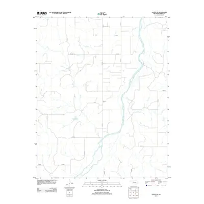
2012 Map of Aledo NE
USGS Topo · Published 2012About this map
The Canadian River winds through this section of Dewey County, defining a landscape of braided channels and shifting sandbars. This 2012 survey illustrates the rural nature of western Oklahoma, where the land is partitioned by a strict grid of county roads like n2210 RD and e0750. Located centrally near one of these intersections is the Raymond Cem, a key landmark for local genealogists and historians tracing the families who settled this prairie region. Surface water management is evident through features such as the Chain Number 3 Reservoir, which captures runoff from the surrounding drainage basins of Lone Cr, Sand Cr, and Sorter Cr. This map documents the persistent agricultural and ranching patterns of the area, where the vast majority of the terrain remains open land punctuated only by remote farmsteads and the intermittent flow of prairie creeks.
Find a feature on this map
23 named features on this map. Tap any name to fly to it.
Don’t see what you’re looking for? This feature index may not catch every label — zoom into the map to look around manually.
Map Details
Editions of this 2012 Aledo NE Map
This is the sole edition of this map. No revisions or reprints were ever made.
Other maps of this area

1955 · Clinton
USGS Topo · 1:250,000

1955 · Woodward
USGS Topo · 1:250,000

1957 · Clinton
USGS Topo · 1:250,000

1958 · Woodward
USGS Topo · 1:250,000

1962 · Putnam
USGS Topo · 1:62,500

1962 · Aledo
USGS Topo · 1:62,500

1969 · Mutual SW
USGS Topo · 1:24,000

1969 · Lenora
USGS Topo · 1:24,000
1972 · Taloga
USGS Topo · 1:24,000

1984 · Foss Reservoir
USGS Topo · 1:100,000