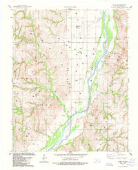
1985 Map of Aledo NE
USGS Topo · Published 1985About this map
The Canadian River dominates this landscape in Dewey County, winding through a region heavily defined by mid-century energy development and rural land use. The river's broad, shifting bed separates the eastern flats from the dissected breaks to the west. While much of the terrain is marked by the presence of numerous extraction points, including a Gas Plant, a Compressor Station, and various Oil Wells, evidence of traditional ranching persists with features like the Corral in the southern sections. Local genealogy is anchored by the Raymond Cem, which sits on a rise above a bend in the river. Significant local drainages such as Sand Creek, Lone Creek, and Sorter Creek feed into the main river valley, illustrating the natural watershed that supported early settlement before the widespread introduction of industrial infrastructure.
Find a feature on this map
24 named features on this map. Tap any name to fly to it.
Don’t see what you’re looking for? This feature index may not catch every label — zoom into the map to look around manually.
Map Details
Editions of this 1985 Aledo NE Map
This is the sole edition of this map. No revisions or reprints were ever made.
Other maps of this area

1955 · Clinton
USGS Topo · 1:250,000

1955 · Woodward
USGS Topo · 1:250,000

1957 · Clinton
USGS Topo · 1:250,000

1958 · Woodward
USGS Topo · 1:250,000

1962 · Putnam
USGS Topo · 1:62,500

1962 · Aledo
USGS Topo · 1:62,500

1969 · Mutual SW
USGS Topo · 1:24,000

1969 · Lenora
USGS Topo · 1:24,000
1972 · Taloga
USGS Topo · 1:24,000

1984 · Foss Reservoir
USGS Topo · 1:100,000