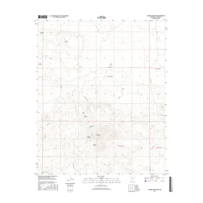
2017 Map of Alegres Mountain
USGS Topo · Published 2017About this map
Alegres Mountain dominates the central topography of this Catron County landscape, surrounded by a complex system of drainage draws and high-altitude springs. In the northern reaches, small cattle tanks like Mann Tank and Brannon Tank suggest the ranching history of the area, while the presence of Johnson Cem and Divide Cem along the roads provides vital touchpoints for local family histories. The terrain is deeply inscribed with names like Pancake Draw and Thaeger Draw, feeding into a network of intermittent water sources including Hubble Spring and Suezzea Spring. The map documents the primitive road network used by locals and forest travelers, including Ed Jones Rd and Greens Gap Rd, which connect these remote mountain features and the many seasonal springs like Quaking Aspen Spring that dot the slopes.
Find a feature on this map
38 named features on this map. Tap any name to fly to it.
Don’t see what you’re looking for? This feature index may not catch every label — zoom into the map to look around manually.
Map Details
Editions of this 2017 Alegres Mountain Map
This is the sole edition of this map. No revisions or reprints were ever made.
Other maps of this area

1954 · Saint Johns
USGS Topo · 1:250,000

1957 · Saint Johns
USGS Topo · 1:250,000

1958 · Saint Johns
USGS Topo · 1:250,000

1962 · Saint Johns
USGS Topo · 1:250,000

1967 · Omega
USGS Topo · 1:24,000
1967 · Red Flats
USGS Topo · 1:24,000
1967 · Pie Town
USGS Topo · 1:24,000
1981 · Cox Peak
USGS Topo · 1:24,000
1981 · Mangas Mountain
USGS Topo · 1:24,000
1981 · Wallace Mesa
USGS Topo · 1:24,000