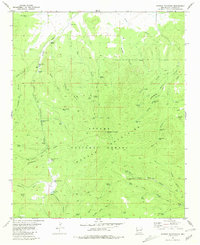
1981 Map of Mangas Mountain
USGS Topo · Published 1981About this map
The Apache National Forest dominates this section of New Mexico, where the Continental Divide winds through the high-elevation landscape of the Mangas Mountains. The topography is defined by a dense network of water-management features critical for forestry and ranching, such as the Mangas Work Center, numerous named tanks like Sleeping Steer Tank, and windmills including Padilla Windmill. This 1981 edition, based on earlier aerial photography, captures the remote character of Catron County as it functioned through mid-century resource management.
Find a feature on this map
69 named features on this map. Tap any name to fly to it.
Don’t see what you’re looking for? This feature index may not catch every label — zoom into the map to look around manually.
Map Details
Editions of this 1981 Mangas Mountain Map
This is the sole edition of this map. No revisions or reprints were ever made.
Other maps of this area

1918 · Pelona
USGS Topo · 1:125,000

1954 · Clifton
USGS Topo · 1:250,000

1954 · Saint Johns
USGS Topo · 1:250,000

1957 · Clifton
USGS Topo · 1:250,000

1957 · Saint Johns
USGS Topo · 1:250,000

1958 · Clifton
USGS Topo · 1:250,000

1958 · Saint Johns
USGS Topo · 1:250,000

1962 · Clifton
USGS Topo · 1:250,000

1962 · Saint Johns
USGS Topo · 1:250,000
1981 · Bell Peak
USGS Topo · 1:24,000