
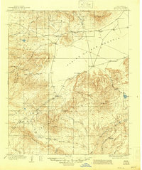
1918 Map of Pelona
USGS Topo · Published 1918About this map
Plains of San Agustin dominate the central topography of this 1918 New Mexico survey, creating a vast flat basin flanked by the Datil Mountains and the Tularosa Range. The map documents a period of early ranching and transit, noted by scattered homesteads like the Sanchez Ranch and Gutierrez Ranch along the northern road. The presence of the Horse Spr Stage Station marks an important stop for travelers through this arid high-desert landscape. Much of the southern and western territory is protected within the Datil National Forest, where steep canyons like Dark Canyon and Long Canyon cut through the volcanic terrain. Genealogists and researchers will find localized landmarks such as the O Bar O Ranch and Collins Camp, providing evidence of early settlement patterns before modern infrastructure reached this part of Socorro County.
Find a feature on this map
41 named features on this map. Tap any name to fly to it.
Don’t see what you’re looking for? This feature index may not catch every label — zoom into the map to look around manually.
Map Details
Editions of this 1918 Pelona Map
2 editions found
Other maps of this area

1910 · Mogollon
USGS Topo · 1:125,000

1911 · Alum Mountain
USGS Topo · 1:125,000

1912 · Mogollon
USGS Topo · 1:125,000

1913 · Alum Mountain
USGS Topo · 1:125,000

1915 · Reserve
USGS Topo · 1:125,000

1918 · Reserve
USGS Topo · 1:125,000

1949 · Lookout Mountain
USGS Topo · 1:62,500

1954 · Tularosa
USGS Topo · 1:250,000

1954 · Clifton
USGS Topo · 1:250,000

1954 · Saint Johns
USGS Topo · 1:250,000