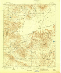
1918 Map of Pelona
USGS Topo · Published 1946About this map
The Plains of San Agustin dominate this 1915-1916 survey, representing a vast high-altitude basin where early ranching life and transportation routes converged. This period in Catron County reveals a landscape structured by water access and stage travel, notably at the Horse Spr Stage Station where the Magdalena Road meets the western highlands. Ranching families established significant holdings across the flats and foothills, including the Fullerton Ranch, Gutierrez Ranch, and the Tut Ranch.
Find a feature on this map
50 named features on this map. Tap any name to fly to it.
Don’t see what you’re looking for? This feature index may not catch every label — zoom into the map to look around manually.
Map Details
Editions of this 1918 Pelona Map
2 editions found
Other maps of this area

1910 · Mogollon
USGS Topo · 1:125,000

1911 · Alum Mountain
USGS Topo · 1:125,000

1912 · Mogollon
USGS Topo · 1:125,000

1913 · Alum Mountain
USGS Topo · 1:125,000

1915 · Reserve
USGS Topo · 1:125,000

1918 · Pelona
USGS Topo · 1:125,000

1918 · Reserve
USGS Topo · 1:125,000

1949 · Lookout Mountain
USGS Topo · 1:62,500

1954 · Tularosa
USGS Topo · 1:250,000

1954 · Clifton
USGS Topo · 1:250,000