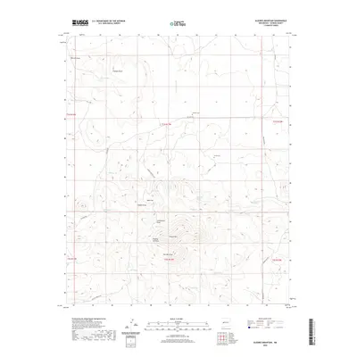
2020 Map of Alegres Mountain
USGS Topo · Published 2020About this map
Alegres Mtn rises above the high-altitude landscape of Catron County, anchoring a terrain defined by complex drainage systems and isolated springs. The presence of Johnson Cem off Ed Jones RD and Divide Cem near the intersection of FR 064a provides critical touchpoints for family historians tracing roots in this rural New Mexico region. This landscape is a network of draws and flats, where Saw Mill Draw and Dipping Vat Draw suggest the historical activities of early ranchers and timber workers who relied on water sources like Quaking Aspen Spring and Bear Spring. The arrangement of these landmarks along routes such as Pie Town Rd and Greens Gap Rd illustrates how settlement patterns were dictated by the availability of water in a semi-arid environment, with named tanks like Mann Tank serving as essential infrastructure.
Find a feature on this map
40 named features on this map. Tap any name to fly to it.
Don’t see what you’re looking for? This feature index may not catch every label — zoom into the map to look around manually.
Map Details
Editions of this 2020 Alegres Mountain Map
This is the sole edition of this map. No revisions or reprints were ever made.
Other maps of this area

1954 · Saint Johns
USGS Topo · 1:250,000

1957 · Saint Johns
USGS Topo · 1:250,000

1958 · Saint Johns
USGS Topo · 1:250,000

1962 · Saint Johns
USGS Topo · 1:250,000

1967 · Omega
USGS Topo · 1:24,000
1967 · Red Flats
USGS Topo · 1:24,000
1967 · Pie Town
USGS Topo · 1:24,000
1981 · Cox Peak
USGS Topo · 1:24,000
1981 · Mangas Mountain
USGS Topo · 1:24,000
1981 · Wallace Mesa
USGS Topo · 1:24,000