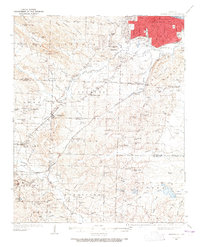
1935 Map of Alexander
USGS Topo · Published 1965About this map
Little Rock sprawls into the northern edge of this mid-1930s survey, marked by the State Hospital and the state Penitentiary near Roosevelt Road. The landscape to the south and west transitions into rural communities and industrial sites, notably the mining operation at Dirtdauber within the Bauxite district. Transportation is defined by the Missouri Pacific and Chicago Rock Island and Pacific railroads, which connect the rail hub at Biddle to outlying towns like Alexander and Mabelvale. Local life in the Fourche and Hurricane townships is anchored by a dense network of small institutions, including Crystal Valley Ch, Base Line Sch, and the Industrial Home near Collegeville. The map illustrates the early 20th-century development of the region before the post-war expansion of the state capital, preserving the locations of numerous family-named landmarks and country schools.
Find a feature on this map
110 named features on this map. Tap any name to fly to it.
Don’t see what you’re looking for? This feature index may not catch every label — zoom into the map to look around manually.
Map Details
Editions of this 1935 Alexander Map
2 editions found
Other maps of this area

1890 · Benton
USGS Topo · 1:125,000

1891 · Little Rock
USGS Topo · 1:125,000

1893 · Little Rock
USGS Topo · 1:125,000

1894 · Benton
USGS Topo · 1:125,000

1932 · Pastoria
USGS Topo · 1:62,500

1935 · Mc Almont
USGS Topo · 1:24,000

1935 · Little Rock
USGS Topo · 1:24,000

1935 · Sweet Home
USGS Topo · 1:24,000

1935 · North Little Rock
USGS Topo · 1:24,000

1935 · Alexander
USGS Topo · 1:48,000