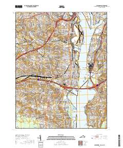
2019 Map of Alexandria
USGS Topo · Published 2019About this map
Arlington Cemetery and the Pentagon Reservation dominate the northern landscape where Arlington County meets the District of Columbia. This survey reveals the dense urban and suburban residential corridors of Northern Virginia, featuring established neighborhoods such as Arlington Heights, Shirlington, and Arlandria. The Potomac River serves as the central artery, with significant federal installations like Fort Myer and Jbab Anacostia-Bolling bordering its banks. Local history is deeply embedded in the map's details, from the Syphax Family Graveyard and Lomax AME Zion Church Cem to the Contraband and Freedmen Memorial Cem in Alexandria. The transportation infrastructure is heavily represented, featuring Ronald Reagan Washington National Airport and major crossings like the Woodrow Wilson Memorial Bridge connecting Virginia to Maryland.
Find a feature on this map
182 named features on this map. Tap any name to fly to it.
Don’t see what you’re looking for? This feature index may not catch every label — zoom into the map to look around manually.
Map Details
Editions of this 2019 Alexandria Map
This is the sole edition of this map. No revisions or reprints were ever made.
Other maps of this area

1890 · Mt. Vernon
USGS Topo · 1:125,000

1891 · Mt. Vernon
USGS Topo · 1:125,000

1892 · Brandywine
USGS Topo · 1:62,500

1894 · Mt. Vernon
USGS Topo · 1:125,000

1895 · Brandywine
USGS Topo · 1:62,500

1897 · Mt. Vernon
USGS Topo · 1:125,000

1899 · Patuxent
USGS Topo · 1:125,000

1900 · Washington
USGS Topo · 1:62,500

1906 · Patuxent
USGS Topo · 1:125,000

1911 · Brandywine
USGS Topo · 1:62,500