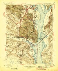
1945 Map of Alexandria
USGS Topo · Published 1945About this map
Alexandria and its northern neighbors appear at a critical wartime juncture, showing the recently completed Pentagon Building and the vast logistics hub of Potomac Yard. This 1941-1942 revision captures the dense concentration of Civil War-era fortifications that ringed the capital, such as Fort Ward, Fort Lyon, and Fort Foote, many of which dictated the later layout of neighborhoods like Shooters Hill and Beverly Hills. The landscape is dominated by institutional and military footprints, from Arlington National Cemetery and Fort Myer Military Reservation to St Elizabeths Hospital across the Potomac River.
Find a feature on this map
129 named features on this map. Tap any name to fly to it.
Don’t see what you’re looking for? This feature index may not catch every label — zoom into the map to look around manually.
Map Details
Editions of this 1945 Alexandria Map
This is the sole edition of this map. No revisions or reprints were ever made.
Other maps of this area

1890 · Mt. Vernon
USGS Topo · 1:125,000

1891 · Mt. Vernon
USGS Topo · 1:125,000

1892 · Brandywine
USGS Topo · 1:62,500

1894 · Mt. Vernon
USGS Topo · 1:125,000

1895 · Brandywine
USGS Topo · 1:62,500

1897 · Mt. Vernon
USGS Topo · 1:125,000

1899 · Patuxent
USGS Topo · 1:125,000

1900 · Washington
USGS Topo · 1:62,500

1906 · Patuxent
USGS Topo · 1:125,000

1911 · Brandywine
USGS Topo · 1:62,500