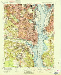
1951 Map of Alexandria
USGS Topo · Published 1951About this map
The Pentagon Building and the sprawling grounds of Arlington National Cemetery anchor the northern landscape of this mid-century Potomac River study. Following the 1949 revision, the map documents the dense suburban expansion of Northern Virginia, where neighborhoods like Shirlington, Parkfairfax, and Arlington Village represent the rapid post-war residential development. Along the riverfront, industrial and military footprints are prominent, from the Potomac Yard rail facility and National Airport to the Naval Research Lab and Bolling Field on the eastern bank.
Find a feature on this map
154 named features on this map. Tap any name to fly to it.
Don’t see what you’re looking for? This feature index may not catch every label — zoom into the map to look around manually.
Map Details
Editions of this 1951 Alexandria Map
This is the sole edition of this map. No revisions or reprints were ever made.
Other maps of this area

1890 · Mt. Vernon
USGS Topo · 1:125,000

1891 · Mt. Vernon
USGS Topo · 1:125,000

1892 · Brandywine
USGS Topo · 1:62,500

1894 · Mt. Vernon
USGS Topo · 1:125,000

1895 · Brandywine
USGS Topo · 1:62,500

1897 · Mt. Vernon
USGS Topo · 1:125,000

1899 · Patuxent
USGS Topo · 1:125,000

1900 · Washington
USGS Topo · 1:62,500

1906 · Patuxent
USGS Topo · 1:125,000

1911 · Brandywine
USGS Topo · 1:62,500