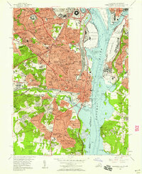
1956 Map of Alexandria
USGS Topo · Published 1958About this map
Alexandria and southern Arlington Co are shown here during a period of massive post-war expansion. The dense rail operations at Potomac Yards and the early footprint of Washington National Airport dominate the waterfront, while the Richmond Fredericksburg And Potomac RR and Southern RY corridor provide the industrial spine for the region. Significant institutional landmarks appear, such as the Virginia Theological Seminary and St Elizabeths Hospital, alongside sprawling residential developments like Arlandria and Bucknell Manor. In the District, Fort Mc Nair and the Us Naval Gun Factory stand as major military hubs across the Anacostia River from Bolling Air Force Base. The map reveals the intricate network of local schools and churches, including Episcopal High Sch and St Marys Ch, that formed the core of these growing Virginia neighborhoods.
Find a feature on this map
232 named features on this map. Tap any name to fly to it.
Don’t see what you’re looking for? This feature index may not catch every label — zoom into the map to look around manually.
Map Details
Editions of this 1956 Alexandria Map
This is the sole edition of this map. No revisions or reprints were ever made.
Other maps of this area

1890 · Mt. Vernon
USGS Topo · 1:125,000

1891 · Mt. Vernon
USGS Topo · 1:125,000

1892 · Brandywine
USGS Topo · 1:62,500

1894 · Mt. Vernon
USGS Topo · 1:125,000

1895 · Brandywine
USGS Topo · 1:62,500

1897 · Mt. Vernon
USGS Topo · 1:125,000

1899 · Patuxent
USGS Topo · 1:125,000

1900 · Washington
USGS Topo · 1:62,500

1906 · Patuxent
USGS Topo · 1:125,000

1911 · Brandywine
USGS Topo · 1:62,500