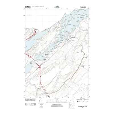
2011 Map of Alexandria Bay
USGS Topo · Published 2011About this map
Alexandria Bay serves as the focal point for this Thousand Islands study, situated along the Saint Lawrence River where the international border separates New York from Canada. The map illustrates a dense landscape of riverfront infrastructure and island estates, most notably the landmark Boldt Castle on Heart Island. Navigation is a primary theme of the region, marked by the Pullman Shoal Lighthouse, the Leading Light, and the R.T. Clayton Vessel Traffic Control station at Collins Landing. Inland from the river, the terrain transitions to a patchwork of agricultural lands and smaller settlements like Omar and Alexandria Center. For genealogists, the map is particularly useful for locating several rural burial sites, including the Houghton Cemetery and Saint Cyriel Cemetery. Transportation corridors are anchored by the Thousand Islands Bridge, which links the mainland to Wellesley Island and points north.
Find a feature on this map
118 named features on this map. Tap any name to fly to it.
Don’t see what you’re looking for? This feature index may not catch every label — zoom into the map to look around manually.
Map Details
Editions of this 2011 Alexandria Bay Map
This is the sole edition of this map. No revisions or reprints were ever made.
Other maps of this area

1900 · Clayton
USGS Topo · 1:62,500

1903 · Grindstone
USGS Topo · 1:62,500

1903 · Clayton
USGS Topo · 1:62,500

1903 · Alexandria Bay
USGS Topo · 1:62,500

1903 · Theresa
USGS Topo · 1:62,500

1942 · Clayton
USGS Topo · 1:24,000

1943 · Thousand Island Park
USGS Topo · 1:31,680

1943 · Redwood
USGS Topo · 1:31,680

1943 · Clayton
USGS Topo · 1:31,680

1943 · Lafargeville
USGS Topo · 1:31,680