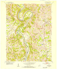
1953 Map of Alexandria
USGS Topo · Published 1955About this map
The Licking River carves a dramatic path through the Kentucky landscape, most notably at the sharp oxbow of Grand Bend. This mid-century survey reveals a rural region defined by its transportation corridors, where the Louisville and Nashville railroad tracks follow the river's winding course through settlements like Visalia and Ryland. To the east, the community of Alexandria sits atop the higher ground, anchored by the Alexandria Pike. The map provides significant detail for genealogists, identifying localized landmarks such as the Tenmile House and Aspen Grove, alongside several rural congregations including Pleasant Ridge Ch and Pilgrim Ch. The boundary between Kenton and Campbell counties is clearly delineated as it weaves through the hills, separating established hilltop towns from the smaller riverfront communities like Springlake and Hawthorne.
Find a feature on this map
36 named features on this map. Tap any name to fly to it.
Don’t see what you’re looking for? This feature index may not catch every label — zoom into the map to look around manually.
Map Details
Editions of this 1953 Alexandria Map
This is the sole edition of this map. No revisions or reprints were ever made.
Other maps of this area

1898 · East Cincinnati
USGS Topo · 1:62,500

1914 · East Cincinnati
USGS Topo · 1:62,500

1914 · West Cincinnati
USGS Topo · 1:62,500

1929 · Alexandria
USGS Topo · 1:48,000

1936 · Alexandria
USGS Topo · 1:62,500

1950 · Independence
USGS Topo · 1:24,000

1950 · Walton
USGS Topo · 1:24,000

1950 · Covington
USGS Topo · 1:24,000

1952 · Newport
USGS Topo · 1:24,000

1953 · Withamsville
USGS Topo · 1:24,000