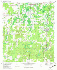
1982 Map of Alford
USGS Topo · Published 1983About this map
The Atlanta and Saint Andrews Bay railroad anchors the eastern corridor of Jackson County, passing through the settlement of Alford and past the distinctive water bodies of Steele City Bay and Round Lake. This 1982 revision illustrates a landscape defined by its unique hydrologic features, where numerous named "bays" — shallow, oval depressions common to the Florida Panhandle — such as Peterson Bay, Buchanan Bay, and Zannie White Bay, dominate the terrain between the elevations of High Hill and Oak Hill.
Find a feature on this map
54 named features on this map. Tap any name to fly to it.
Don’t see what you’re looking for? This feature index may not catch every label — zoom into the map to look around manually.
Map Details
Editions of this 1982 Alford Map
This is the sole edition of this map. No revisions or reprints were ever made.
Other maps of this area
1950 · Chipley
USGS Topo · 1:24,000
1950 · Wausau
USGS Topo · 1:24,000
1950 · Gap Lake
USGS Topo · 1:24,000
1951 · Chipley
USGS Topo · 1:24,000
1951 · Wausau
USGS Topo · 1:24,000
1951 · Gap Pond
USGS Topo · 1:24,000
1952 · Kynesville
USGS Topo · 1:24,000
1952 · Alford SE
USGS Topo · 1:24,000
1952 · Cottondale East
USGS Topo · 1:24,000
1952 · Cottondale West
USGS Topo · 1:24,000