
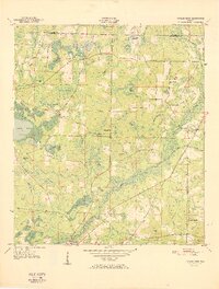
1950 Map of Chipley
USGS Topo · Published 1966About this map
Chipley serves as the primary hub of this 1950 topographical survey, situated at the convergence of the Louisville and Nashville railroad and the Old Spanish Trail. The landscape is a network of named wetlands and water bodies, including Double Spring Bay, Wolf Bay, and Duck Pd, which define the drainage patterns of Holmes Creek and Alligator Creek. This era of development is marked by rural outposts such as Richter Crossroads and Bahoma, alongside vital community landmarks like Salem Ch and Poplar Springs Ch. To the south, the Chipley Landing Field reflects mid-century aviation infrastructure, while numerous family-named landmarks like Hicks Hill and Watts Pond provide specific points of interest for genealogists tracing local land ownership and settlement patterns across the Jackson and Washington county lines.
Find a feature on this map
44 named features on this map. Tap any name to fly to it.
Don’t see what you’re looking for? This feature index may not catch every label — zoom into the map to look around manually.
Map Details
Editions of this 1950 Chipley Map
This is the sole edition of this map. No revisions or reprints were ever made.
Other maps of this area

1950 · Wausau
USGS Topo · 1:24,000

1950 · Esto
USGS Topo · 1:24,000

1950 · Poplar Head
USGS Topo · 1:24,000

1951 · Graceville
USGS Topo · 1:24,000

1951 · Esto
USGS Topo · 1:24,000

1951 · Chipley
USGS Topo · 1:24,000

1951 · Wausau
USGS Topo · 1:24,000
1951 · Poplar Head
USGS Topo · 1:24,000

1951 · Bonifay
USGS Topo · 1:24,000

1952 · Campbellton
USGS Topo · 1:24,000