
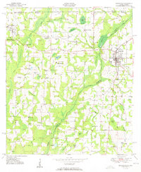
1951 Map of Graceville
USGS Topo · Published 1951About this map
Graceville serves as the primary hub of this landscape, situated at the intersection of the Louisville and Nashville railroad and local trade routes. The surrounding rural area is defined by a dense network of water features and named hills, illustrating the intricate hydrology of the Panhandle before significant modern alterations. Landmarks such as Collins Mill and the whimsically named Hog and Hominy Road suggest a traditional agrarian economy tied to milling and livestock.
Find a feature on this map
63 named features on this map. Tap any name to fly to it.
Don’t see what you’re looking for? This feature index may not catch every label — zoom into the map to look around manually.
Map Details
Editions of this 1951 Graceville Map
2 editions found
Other maps of this area

1942 · Enterprise
USGS Topo · 1:125,000

1950 · Chipley
USGS Topo · 1:24,000

1950 · Esto
USGS Topo · 1:24,000

1951 · Esto
USGS Topo · 1:24,000

1951 · Chipley
USGS Topo · 1:24,000

1951 · Bonifay
USGS Topo · 1:24,000

1952 · Campbellton
USGS Topo · 1:24,000

1952 · Cottondale West
USGS Topo · 1:24,000

1953 · Dothan
USGS Topo · 1:250,000

1954 · Dothan
USGS Topo · 1:250,000