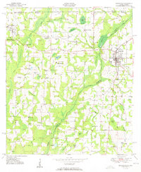
1951 Map of Graceville
USGS Topo · Published 1951About this map
Graceville and Noma serve as the primary anchors for this 1950s survey of the borderlands where the Florida Panhandle meets Alabama. The landscape is a network of small settlements and family landmarks defined by the winding course of Holmes Creek and its many tributaries like Wrights Creek and Little Creek. The area’s infrastructure is deeply tied to the Louisville and Nashville railroad, which crosses the northern section at Noma Junction and Underwood Crossing. Local transit follows historic routes with colorful names such as the Hog and Hominy Road and Reddick Mill Road. Scattered throughout the rural landscape are numerous community centers for the era’s farming families, including Poplar Springs Sch, Bethel Ch, and Newhome Ch. This map records a time of decentralized community life, evidenced by the high density of country schools and churches situated at rural crossroads like Cobb Cross Roads.
Find a feature on this map
69 named features on this map. Tap any name to fly to it.
Don’t see what you’re looking for? This feature index may not catch every label — zoom into the map to look around manually.
Map Details
Editions of this 1951 Graceville Map
2 editions found
Other maps of this area

1942 · Enterprise
USGS Topo · 1:125,000

1950 · Chipley
USGS Topo · 1:24,000

1950 · Esto
USGS Topo · 1:24,000

1951 · Graceville
USGS Topo · 1:24,000

1951 · Esto
USGS Topo · 1:24,000

1951 · Chipley
USGS Topo · 1:24,000

1951 · Bonifay
USGS Topo · 1:24,000

1952 · Campbellton
USGS Topo · 1:24,000

1952 · Cottondale West
USGS Topo · 1:24,000

1953 · Dothan
USGS Topo · 1:250,000