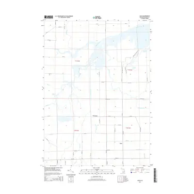
2014 Map of Alicia
USGS Topo · Published 2014About this map
Alicia and Clausedale center this map of the Albee Township region, where a complex network of waterways defines the landscape. The confluence of the Shiawassee River and the Flint River creates a distinctive environment of lowlands and bayous, including Ferguson Bayou and Crystal Bayou. This drainage pattern is further characterized by numerous tributaries such as Bad River, Swan Creek, and Misteguay Creek, which reflect the area's history as a critical hydrologic crossroads in Saginaw County. A strictly gridded road system, featuring routes like Hart Rd and Bishop Rd, overlays the meandering river courses, illustrating the intersection of modern agricultural development with the natural riverine environment. Local geography is further enriched by named features like Kimberly Bayou and the Ferguson Bayou Nature Trail, highlighting the area's focus on its waterway resources.
Find a feature on this map
55 named features on this map. Tap any name to fly to it.
Don’t see what you’re looking for? This feature index may not catch every label — zoom into the map to look around manually.
Map Details
Editions of this 2014 Alicia Map
This is the sole edition of this map. No revisions or reprints were ever made.
Other maps of this area

1917 · Chesaning
USGS Topo · 1:62,500

1917 · St. Charles
USGS Topo · 1:62,500

1919 · Saginaw
USGS Topo · 1:62,500

1919 · Burt
USGS Topo · 1:62,500

1921 · Burt
USGS Topo · 1:62,500

1941 · Saginaw
USGS Topo · 1:62,500

1943 · Burt
USGS Topo · 1:62,500

1943 · Chesaning
USGS Topo · 1:62,500

1943 · Saginaw
USGS Topo · 1:62,500

1943 · St. Charles
USGS Topo · 1:62,500
Featured Places
- Albee Township, MI
- Swan Creek Township, MI
- James Township, MI
- Spaulding Township, MI
- Saint Charles Township, MI