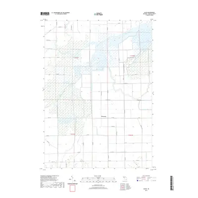
2019 Map of Alicia
USGS Topo · Published 2019About this map
The Shiawassee River and Flint River converge in this low-lying portion of Albee Township, creating a complex network of wetlands and bayous characteristic of the Saginaw Valley. This drainage system is further defined by substantial tributaries like Misteguay Creek, Swan Creek, and the Bad River. The small settlement of Clausedale stands as a focal point in the agricultural landscape south of the river bottoms, where the land transitions from saturated marshlands to a grid of rural section roads. For researchers, the map details the intricate hydrography of the region, featuring named landmarks such as Crystal Bayou and Kimberly Bayou. The presence of the Ferguson Bayou Nature Trail indicates the modern conservation and recreational use of these historical wetlands, which have long dictated the settlement patterns and transportation routes through this part of Saginaw County.
Find a feature on this map
57 named features on this map. Tap any name to fly to it.
Don’t see what you’re looking for? This feature index may not catch every label — zoom into the map to look around manually.
Map Details
Editions of this 2019 Alicia Map
This is the sole edition of this map. No revisions or reprints were ever made.
Other maps of this area

1917 · Chesaning
USGS Topo · 1:62,500

1917 · St. Charles
USGS Topo · 1:62,500

1919 · Saginaw
USGS Topo · 1:62,500

1919 · Burt
USGS Topo · 1:62,500

1921 · Burt
USGS Topo · 1:62,500

1941 · Saginaw
USGS Topo · 1:62,500

1943 · Burt
USGS Topo · 1:62,500

1943 · Chesaning
USGS Topo · 1:62,500

1943 · Saginaw
USGS Topo · 1:62,500

1943 · St. Charles
USGS Topo · 1:62,500
Featured Places
- Albee Township, MI
- Swan Creek Township, MI
- James Township, MI
- Spaulding Township, MI
- Saint Charles Township, MI