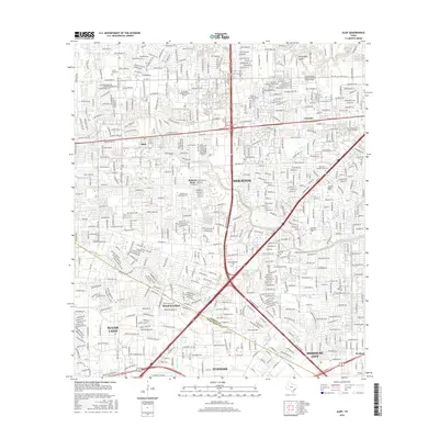
2016 Map of Alief
USGS Topo · Published 2016About this map
Houston and its southwest suburbs present a dense network of residential streets and commercial corridors in this mid-2010s survey. The map records the complex municipal boundaries where Harris Co meets Fort Bend Co, encompassing established communities like Alief and newer incorporated areas such as Meadows Place. The landscape is defined by its drainage systems, with Buffalo Bayou and Brays Bayou channeling water through the metropolitan sprawl. This edition is particularly useful for identifying the specific locations of several regional institutions, including Houston Baptist Univ and the Remington College-Houston Campus. Notable for family historians, the sheet identifies multiple burial grounds such as Alief Cem, Riceville Cem, and the expansive Forest Park Cem. The transition from the urban core of Houston to neighboring municipalities like Sugar Land, Stafford, and Missouri City is captured through an intricate grid of secondary highways and local roads like FM 1093 and Alief Clodine Rd.
Find a feature on this map
61 named features on this map. Tap any name to fly to it.
Don’t see what you’re looking for? This feature index may not catch every label — zoom into the map to look around manually.
Map Details
Editions of this 2016 Alief Map
This is the sole edition of this map. No revisions or reprints were ever made.
Other maps of this area

1915 · Bellaire
USGS Topo · 1:24,000

1915 · Houston Heights
USGS Topo · 1:24,000

1915 · Alief
USGS Topo · 1:24,000

1915 · Addicks
USGS Topo · 1:24,000

1915 · Hillendahl
USGS Topo · 1:24,000

1915 · Clodine
USGS Topo · 1:24,000

1918 · Addicks
USGS Topo · 1:31,680

1918 · Hillendahl
USGS Topo · 1:31,680

1919 · Clodine
USGS Topo · 1:31,680

1920 · Almeda
USGS Topo · 1:31,680