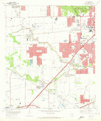
1970 Map of Alief
USGS Topo · Published 1973About this map
The southwest expansion of Houston into the ranch lands and rice fields of the coastal prairie is clearly visible in this 1970 snapshot. Modern suburban developments like Bellaire West and Sharpstown are rapidly filling the space between the historic community of Alief and the industrial corridors of Sugar Land and Stafford. The landscape is transitioning from open drainage systems like Keegans Bayou and Brays Bayou to a structured grid of residential streets and essential community institutions.
Find a feature on this map
49 named features on this map. Tap any name to fly to it.
Don’t see what you’re looking for? This feature index may not catch every label — zoom into the map to look around manually.
Map Details
Editions of this 1970 Alief Map
This is the sole edition of this map. No revisions or reprints were ever made.
Other maps of this area

1915 · Bellaire
USGS Topo · 1:24,000

1915 · Houston Heights
USGS Topo · 1:24,000

1915 · Alief
USGS Topo · 1:24,000

1915 · Addicks
USGS Topo · 1:24,000

1915 · Hillendahl
USGS Topo · 1:24,000

1915 · Clodine
USGS Topo · 1:24,000

1918 · Addicks
USGS Topo · 1:31,680

1918 · Hillendahl
USGS Topo · 1:31,680

1919 · Clodine
USGS Topo · 1:31,680

1920 · Almeda
USGS Topo · 1:31,680