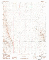
1985 Map of Alivio
USGS Topo · Published 1985About this map
The eastern flanks of the Caballo Mountains and the McLeod Hills dominate the western landscape of this mid-1980s New Mexico survey. In the valley below, the Atchison Topeka and Santa Fe railroad runs parallel to a long Levee system, serving the small settlement of Alivio. This transport corridor traces the desert floor between the high peaks to the west and the distinctive formation known as Point of Rocks to the east.
Find a feature on this map
19 named features on this map. Tap any name to fly to it.
Don’t see what you’re looking for? This feature index may not catch every label — zoom into the map to look around manually.
Map Details
Editions of this 1985 Alivio Map
This is the sole edition of this map. No revisions or reprints were ever made.
Other maps of this area

1916 · Tonuco
USGS Topo · 1:125,000

1932 · Tonuco
USGS Topo · 1:125,000

1948 · Chicken Well
USGS Topo · 1:62,500

1948 · San Diego Mountain
USGS Topo · 1:62,500

1955 · Las Cruces
USGS Topo · 1:250,000

1958 · Las Cruces
USGS Topo · 1:250,000

1959 · Hatch
USGS Topo · 1:24,000

1959 · Rincon
USGS Topo · 1:24,000

1959 · Upham
USGS Topo · 1:62,500
1981 · Prisor Hill
USGS Topo · 1:24,000