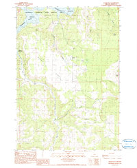
1990 Map of Alkali Flat
USGS Topo · Published 1999About this map
The Prineville Reservoir State Wildlife Area dominates the northern reaches of this Crook County landscape, where the waters of the Crooked River meet the Prineville Reservoir. The terrain is defined by dramatic elevation shifts, rising from the water's edge up to Windy Point and the prominent Alkali Butte to the east. The central basin of Alkali Flat and the winding Alkali Canyon suggest a semi-arid environment shaped by seasonal water flow through drainages like Salt Creek and Home Hollow Creek.
Find a feature on this map
22 named features on this map. Tap any name to fly to it.
Don’t see what you’re looking for? This feature index may not catch every label — zoom into the map to look around manually.
Map Details
Editions of this 1990 Alkali Flat Map
This is the sole edition of this map. No revisions or reprints were ever made.
Other maps of this area

1946 · Eagle Rock
USGS Topo · 1:62,500

1948 · Eagle Rock
USGS Topo · 1:62,500

1955 · Crescent
USGS Topo · 1:250,000

1955 · Bend
USGS Topo · 1:250,000

1957 · Crescent
USGS Topo · 1:250,000

1957 · Bend
USGS Topo · 1:250,000

1958 · Crescent
USGS Topo · 1:250,000

1958 · Bend
USGS Topo · 1:250,000

1962 · Powell Buttes
USGS Topo · 1:62,500

1967 · Brothers NW
USGS Topo · 1:24,000