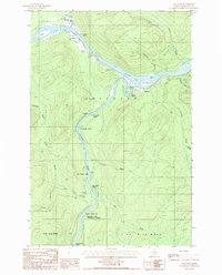
1986 Map of Allagash
USGS Topo · Published 1987About this map
The St John River and Allagash River converge in this northern Maine landscape, defining a region where water and timber have long dictated the pace of life. Near the small settlement of Dickey, a Landing Strip and a Gaging Station indicate the area's importance for local transport and hydrological monitoring in the mid-1980s. Further downstream, the village of Allagash sits near the confluence, surrounded by numerous river islands like Hog I and Wolf I.
Find a feature on this map
42 named features on this map. Tap any name to fly to it.
Don’t see what you’re looking for? This feature index may not catch every label — zoom into the map to look around manually.
Map Details
Editions of this 1986 Allagash Map
This is the sole edition of this map. No revisions or reprints were ever made.
Other maps of this area

1930 · Allagash
USGS Topo · 1:48,000

1930 · St Francis
USGS Topo · 1:48,000

1931 · Fish River Lake
USGS Topo · 1:48,000

1932 · Allagash Falls
USGS Topo · 1:48,000

1933 · Allagash
USGS Topo · 1:62,500

1933 · St Francis
USGS Topo · 1:62,500

1935 · Fish River Lake
USGS Topo · 1:62,500

1935 · Allagash Falls
USGS Topo · 1:62,500

1954 · Presque Isle
USGS Topo · 1:250,000

1956 · Allagash Falls
USGS Topo · 1:50,000