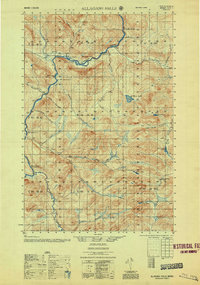
1956 Map of Allagash Falls
USGS Topo · Published 1956About this map
Allagash River and its dramatic Allagash Falls anchor this survey of the North Maine Woods, capturing the landscape as it appeared during the mid-20th century. The territory is defined by a sparse network of logging and sporting outposts rather than established towns, reflecting the region's enduring reliance on the timber industry and river transport. Camps such as Cunliffe Depot Camp and Mc Keen Camp are scattered along the waterways, while Michaud Farm and Moores Farm represent rare pockets of cleared land in the dense forest. Notable hydrological features include the Musquacook Deadwater and the rocky passage at Mc Gargle Rocks. The map also provides a record of various backcountry locations like Rideout Cabin and Joe Martins Camp, which are essential reference points for genealogists and local historians tracking the early settlers and woodsmen of Aroostook County.
Find a feature on this map
41 named features on this map. Tap any name to fly to it.
Don’t see what you’re looking for? This feature index may not catch every label — zoom into the map to look around manually.
Map Details
Editions of this 1956 Allagash Falls Map
2 editions found

Other maps of this area

1930 · Allagash
USGS Topo · 1:48,000

1930 · St Francis
USGS Topo · 1:48,000

1931 · Fish River Lake
USGS Topo · 1:48,000

1931 · Mooseleuk Lake
USGS Topo · 1:48,000

1932 · Umsaskis Lake
USGS Topo · 1:48,000

1932 · Musquacook Lakes
USGS Topo · 1:48,000

1932 · Allagash Falls
USGS Topo · 1:48,000

1933 · Allagash
USGS Topo · 1:62,500

1933 · St Francis
USGS Topo · 1:62,500

1935 · Umsaskis Lake
USGS Topo · 1:62,500