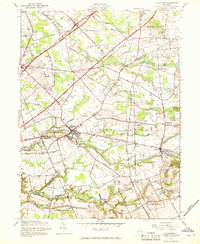
1957 Map of Allentown
USGS Topo · Published 1969About this map
Allentown sits at the heart of this central New Jersey landscape, where the convergence of Doctors Creek and Negro Run reflects a centuries-old reliance on local waterpower. The map illustrates a transitional period for Monmouth Co and Mercer Co, as the modern Pennsylvania New Jersey Turnpike carves through a countryside still defined by small milling hamlets and agricultural crossroads. Smaller settlements like Imlaystown, with its adjacent Imlaystown Lake, and Walnford along the Crosswicks Creek highlight the persistence of 18th-century settlement patterns into the late 1950s.
Find a feature on this map
68 named features on this map. Tap any name to fly to it.
Don’t see what you’re looking for? This feature index may not catch every label — zoom into the map to look around manually.
Map Details
Editions of this 1957 Allentown Map
3 editions found
Other maps of this area

1888 · Bordentown
USGS Topo · 1:62,500

1888 · New Brunswick
USGS Topo · 1:62,500

1888 · Princeton
USGS Topo · 1:62,500

1888 · Cassville
USGS Topo · 1:62,500

1893 · Bordentown
USGS Topo · 1:62,500

1893 · New Brunswick
USGS Topo · 1:62,500

1894 · Princeton
USGS Topo · 1:62,500

1894 · Cassville
USGS Topo · 1:62,500

1900 · Cassville
USGS Topo · 1:62,500

1901 · New Brunswick
USGS Topo · 1:62,500
Featured Places
- Hamilton Township, NJ
- East Windsor Township, NJ
- West Windsor, NJ
- Robbinsville Township, NJ
- Millstone Township, NJ