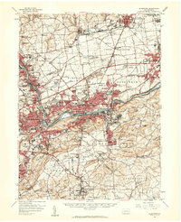
1957 Map of Allentown
USGS Topo · Published 1960About this map
The Lehigh River corridor serves as the industrial and logistical spine for this mid-century survey of the Lehigh Valley. Extensive rail networks including the Reading RR, Lehigh Valley RR, and the Central RR of New Jersey converge on the urban centers, supporting the region's productive quarries and steel-era growth. While the urban cores of Allentown and Bethlehem dominate the center, the landscape transitions into the rolling hills of South Mountain and Saucon Hill to the south.
Find a feature on this map
139 named features on this map. Tap any name to fly to it.
Don’t see what you’re looking for? This feature index may not catch every label — zoom into the map to look around manually.
Map Details
Editions of this 1957 Allentown Map
Other maps of this area

1888 · Quakertown
USGS Topo · 1:62,500

1890 · Easton
USGS Topo · 1:62,500

1890 · Doylestown
USGS Topo · 1:62,500

1890 · Quakertown
USGS Topo · 1:62,500

1891 · Easton
USGS Topo · 1:62,500

1891 · Doylestown
USGS Topo · 1:62,500

1891 · Delaware Water Gap
USGS Topo · 1:62,500

1893 · Delaware Water Gap
USGS Topo · 1:62,500

1894 · Allentown
USGS Topo · 1:62,500

1894 · Quakertown
USGS Topo · 1:62,500