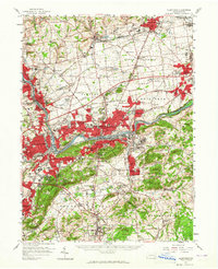
1957 Map of Allentown
USGS Topo · Published 1965About this map
Industrial expansion and postwar suburban growth define the landscape of the Lehigh Valley in the late 1950s. The heavy industrial corridor of Bethlehem and Freemansburg centers on the Lehigh River, where the historic Lehigh Canal and multiple lines of the Reading railroad network intersect. This mid-century view captures the transition from rural agricultural land to residential developments, evidenced by the numerous cemeteries, golf courses like Green Pond Golf Course, and the emergence of neighborhoods such as Palmer Heights and Prospect Park.
Find a feature on this map
140 named features on this map. Tap any name to fly to it.
Don’t see what you’re looking for? This feature index may not catch every label — zoom into the map to look around manually.
Map Details
Editions of this 1957 Allentown Map
Other maps of this area

1888 · Quakertown
USGS Topo · 1:62,500

1890 · Easton
USGS Topo · 1:62,500

1890 · Doylestown
USGS Topo · 1:62,500

1890 · Quakertown
USGS Topo · 1:62,500

1891 · Easton
USGS Topo · 1:62,500

1891 · Doylestown
USGS Topo · 1:62,500

1891 · Delaware Water Gap
USGS Topo · 1:62,500

1893 · Delaware Water Gap
USGS Topo · 1:62,500

1894 · Allentown
USGS Topo · 1:62,500

1894 · Quakertown
USGS Topo · 1:62,500