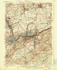
1939 Map of Allentown
USGS Topo · Published 1943About this map
The Lehigh River corridor serves as the industrial and transportation backbone of this region during the 1930s, defined by the heavy infrastructure of the Lehigh and New England RR and the Central RR of New Jersey. The industrial character of the valley is punctuated by a large Cement Plant and the surviving path of the Lehigh Canal, illustrating the evolution from water-based transport to rail and highway. To the north, the Allentown Bethlehem Airport represents the newer era of transit emerging near Shoenersville.
Find a feature on this map
151 named features on this map. Tap any name to fly to it.
Don’t see what you’re looking for? This feature index may not catch every label — zoom into the map to look around manually.
Map Details
Editions of this 1939 Allentown Map
4 editions found

Other maps of this area

1888 · Quakertown
USGS Topo · 1:62,500

1890 · Easton
USGS Topo · 1:62,500

1890 · Doylestown
USGS Topo · 1:62,500

1890 · Quakertown
USGS Topo · 1:62,500

1891 · Easton
USGS Topo · 1:62,500

1891 · Doylestown
USGS Topo · 1:62,500

1891 · Delaware Water Gap
USGS Topo · 1:62,500

1893 · Delaware Water Gap
USGS Topo · 1:62,500

1894 · Allentown
USGS Topo · 1:62,500

1894 · Quakertown
USGS Topo · 1:62,500