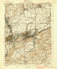
1939 Map of Allentown
USGS Topo · Published 1939About this map
The industrial corridor of the Lehigh River anchors this pre-war landscape, where the dense urban centers of Allentown, Bethlehem, and Catasauqua meet a complex network of railroads including the LV RR and Reading RR. The map illustrates the region's transition from river-dependent manufacturing to the modern aviation era, highlighted by the early footprint of the Allentown Bethlehem Airport. Beyond the urban core, the terrain is dotted with small rural schoolhouses like Schortz Sch and Franklin Sch, alongside traditional settlements such as Shoenersville and Kreidersville. To the south, the topography rises sharply at Lehigh Mountain and South Mountain, overlooking Lehigh University. This survey details an era when local rail lines still connected every small borough, before the large-scale expansion of the interstate system fundamentally altered the Lehigh Valley's spatial organization.
Find a feature on this map
138 named features on this map. Tap any name to fly to it.
Don’t see what you’re looking for? This feature index may not catch every label — zoom into the map to look around manually.
Map Details
Editions of this 1939 Allentown Map
4 editions found

Other maps of this area

1888 · Quakertown
USGS Topo · 1:62,500

1890 · Easton
USGS Topo · 1:62,500

1890 · Doylestown
USGS Topo · 1:62,500

1890 · Quakertown
USGS Topo · 1:62,500

1891 · Easton
USGS Topo · 1:62,500

1891 · Doylestown
USGS Topo · 1:62,500

1891 · Delaware Water Gap
USGS Topo · 1:62,500

1893 · Delaware Water Gap
USGS Topo · 1:62,500

1894 · Allentown
USGS Topo · 1:62,500

1894 · Quakertown
USGS Topo · 1:62,500