
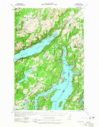
1938 Map of Allyn
USGS Topo · Published 1962About this map
Hood Canal and Case Inlet dominate this coastal survey, where the intricate shoreline of the Puget Sound meets the heavily wooded interior of the Kitsap Peninsula. The map captures the late 1930s landscape of rural Mason, Kitsap, and Pierce counties, marked by small waterfront settlements and an emerging network of state roads. Coastal life centers on sheltered waters like Lynch Cove and North Bay, where the town of Allyn is positioned at the head of the inlet. Inland, the topography is defined by dozens of glacial lakes, including the large Mason Lake and smaller bodies like Benson Lake and Lake Spencer. The map shows early recreational infrastructure at Twanoh State Park and local educational markers such as Grant Sch, documenting a period when these communities relied heavily on the water and new motor routes like State Hwy 14 for connectivity.
Find a feature on this map
50 named features on this map. Tap any name to fly to it.
Don’t see what you’re looking for? This feature index may not catch every label — zoom into the map to look around manually.
Map Details
Editions of this 1938 Allyn Map
2 editions found
Other maps of this area

1936 · Point Misery
USGS Topo · 1:62,500

1937 · Olympia
USGS Topo · 1:62,500

1937 · Port Orchard
USGS Topo · 1:62,500

1938 · Mt Constance
USGS Topo · 1:125,000

1939 · Shelton
USGS Topo · 1:62,500

1940 · Point Misery
USGS Topo · 1:62,500

1940 · Anderson Island
USGS Topo · 1:62,500

1942 · Gig Harbor
USGS Topo · 1:62,500

1943 · Potlatch
USGS Topo · 1:62,500

1943 · Gig Harbor
USGS Topo · 1:62,500