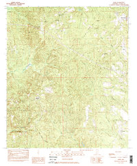
1983 Map of Alma
USGS Topo · Published 1983About this map
The Old Indian Treaty Boundary slices diagonally across this Clarke County landscape, serving as a silent reminder of early territorial demarcations in Alabama. The terrain is defined by a dense network of drainage systems, including Salt Creek, Reedy Creek, and Drummer Creek, which navigate the elevation changes around Roundtop Hill. Much of the southern portion of the quadrangle is dedicated to the Fred T Stimpson State Game Sanctuary, a large protected area bordered by Limestone Creek. Small, dispersed settlements like Rockville and Alma anchor the rural community, while a significant concentration of local churches, such as Mt Sinai No 1 Ch, St Matthews Ch, and Perry Chapel, suggests a landscape shaped by tight-knit congregational life. For genealogists, the map preserves specific burial sites like McGowan Cem, alongside evidence of local industry at the Gravel Pit.
Find a feature on this map
22 named features on this map. Tap any name to fly to it.
Don’t see what you’re looking for? This feature index may not catch every label — zoom into the map to look around manually.
Map Details
Editions of this 1983 Alma Map
2 editions found
Other maps of this area

1943 · Choctaw Bluff
USGS Topo · 1:62,500

1946 · Choctaw Bluff
USGS Topo · 1:62,500

1953 · Andalusia
USGS Topo · 1:250,000

1957 · Andalusia
USGS Topo · 1:250,000

1972 · Chrysler
USGS Topo · 1:24,000

1972 · Gainestown
USGS Topo · 1:24,000

1972 · Suggsville
USGS Topo · 1:24,000

1978 · Jackson
USGS Topo · 1:24,000
1978 · Walker Springs
USGS Topo · 1:24,000
1983 · Prestwick
USGS Topo · 1:24,000